|
|
Garmin eTrex Vista C - GPS receiver - hiking at Backoffice
Garmin eTrex Vista C - GPS receiver - hiking
010-00368-01
|
This product is no longer available.
|
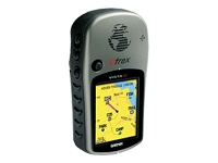
The eTrex Vista C is Garmin's exciting, new, pocket-sized handheld that brings color, automatic routing, longer battery life, plus more to Garmin's popular-selling eTrex Vista. You won't miss a thing when you take this colorful, lightweight, easy-to-use handheld out hiking, biking, boating or even geocaching. The eTrex Vista C along with the eTrex Legend C are Garmin's smallest, least expensive products to combine a color TFT display and advanced GPS routing capabilities in a waterproof design.| Product Description | Garmin eTrex Vista C - GPS receiver | | Product Type | GPS receiver | | Recommended Use | Hiking | | Dimensions (WxDxH) | 5.5 cm x 3.1 cm x 10.5 cm | | Weight | 155 g | | Maps Included | Europe | | Included GPS Software | Garmin Marine Point Database (Americas), Garmin Atlantic Highway Basemap | | Compatible GPS Software | MapSource BlueChart, MapSource Fishing Hot Spots | | Receiver | 12 channel | | SBAS | WAAS | | Connectivity | USB | | GPS Functions / Services | Electronic compass, bearing, elevation, heading, ETA (Estimated Time of Arrival), VMG (Velocity Made Good), speed, ETE (Estimated Time Enroute), time/date, local pressure, ascent/descent rate, 12-hour pressure trend | | Waypoints | 500 | | Tracks | 20 | | Tracklog Points | 10000 | | Routes | 50 | | Built-in Display | LCD - 176 x 220 - colour | | Built-in Memory | 24 MB | | Waterproof | Built-in |
GENERAL |
| Product Type | GPS receiver |
| Width | 5.5 cm |
| Depth | 3.1 cm |
| Height | 10.5 cm |
| Weight | 155 g |
GPS SYSTEM |
| Recommended Use | Hiking |
| Receiver | 12 channel |
| SBAS | WAAS |
| Accuracy | Position - 15 m
Position - 3 m ( with WAAS )
Position - 3 - 5 m ( with DGPS )
Velocity - 0.05 m/sec |
| Update Rate | 1/second |
| Connectivity | USB |
| Interface | Garmin USB |
| GPS Functions / Services | Electronic compass, bearing, elevation, heading, ETA (Estimated Time of Arrival), VMG (Velocity Made Good), speed, ETE (Estimated Time Enroute), time/date, local pressure, ascent/descent rate, 12-hour pressure trend |
| Aerial | Built-in |
| Features | Barometric altimeter, stopwatch |
| Built-in Memory | 24 MB |
| Maps Included | Europe |
| Software Included | Garmin Marine Point Database (Americas), Garmin Atlantic Highway Basemap |
| Compatible GPS Software | MapSource BlueChart, MapSource Fishing Hot Spots |
ACQUISITION TIMES |
| Cold | 45 sec |
| Warm | 15 sec |
NAVIGATION |
| Waypoints | 500 |
| Tracks | 20 |
| Tracklog Points | 10000 |
| Routes | 50 |
| Trip Computer | Average speed, maximum speed, trip timer, trip distance, sunrise/sunset times |
BUILT-IN DISPLAY |
| Type | LCD |
| Resolution | 176 x 220 |
| Diagonal Size | 2" |
| Display Illumination | Yes |
| Colour Support | Colour |
CONNECTIONS |
| Connector Type | Serial - USB |
BATTERY |
| Form Factor | AA type |
| Required Qty | 2 |
| Run Time (Up To) | 20 hour(s) |
MISCELLANEOUS |
| Included Accessories | PC cable, wrist strap |
| Waterproof | Built-in |
| Waterproof Standard | IPX7 |
ENVIRONMENTAL PARAMETERS |
| Min Operating Temperature | -15 °C |
| Max Operating Temperature | 70 °C |
|
|
|


